Ragland
- This article is about the town. For other uses, see Ragland (disambiguation).
| Town of Ragland | |
| Incorporated | 1899 |
|---|---|
| Population | 1,677 |
| Mayor | Richard Bunt |
| School district | St Clair County School System |
| Government |
Ragland Town Council |
| Web site | townofragland.org |

| |
| Locate with Google Maps | |
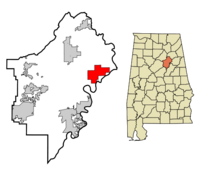
Ragland is a town of 1,677 on 16.9 square miles in St Clair County southeast of Ashville, on the banks of Trout Creek which spills into the Coosa River below the Neely Henry Dam.
The town is home to Ragland High School, built in 1919, which is part of St Clair County Schools. Ragland's main employer is the National Cement Company.
An F4 tornado struck southwest of the town at 10:55 in the morning on Palm Sunday March 27, 1994.
History
The community was originally called Trout Creek. Independent coal mines in the area furnished the Brierfield Ironworks in the 1860s. After the narrow-gauge East and West Railroad of Alabama reached the town in 1881, much of the coal property was acquired by George Ragland, and the town took his name when it was incorporated in 1899. The first Ragland Town Hall was built in 1913. The former Ragland Depot is presently operated as a museum.
The rail connection allowed lumbering and cotton planting to join coal mining as profitable industries. The rail line was rebuilt at standard gauge before it was acquired by the Seaboard Railroad Company in 1902. Once Ragland's soil and coal seams were depleted, the deposits of limestone, shale and clay on "Brickyard Mountain" provided a foundation for brickmaking and cement manufacturing. Allen Green opened the Ragland Brick Company. The National Cement Company was founded in 1908 by W. H. Shaffer and his sons, Edgar and Manasseh.
The Shaffers also built the Ragland Inn, which was operated by Isaac Ledbetter and his wife. Henry Lee built the competing Lee Hotel in 1910. The Bank of Ragland also opened in 1910, but failed in 1932.
Samuel Reed, the town's postmaster, donated land for Ragland Methodist Church, which was built in 1929. The present First Baptist Church of Ragland was constructed in 1931.
Mayors
- Gary Daffron, 2009
- Richard Bunt, 2016-
Demographics
As of the census of 2010, there were 1,639 people, 648 households, and 467 families residing in the town. The population density was 97.6 people per square mile. There were 752 housing units at an average density of 44.8 per square mile. The racial makeup of the town was 83% White and 15% Black or African American.
There were 648 households out of which 27.0% had children under the age of 18 living with them, 52.3% were married couples living together, 15.1% had a female householder with no husband present, and 27.9% were non-families. 25.8% of all households were made up of individuals and 12.8% had someone living alone who was 65 years of age or older. The average household size was 2.53 and the average family size was 3.02.
In the town, the age distribution of the population shows 22.5% under the age of 18, 11.0% from 18 to 24, 23.0% from 25 to 44, 27.6% from 45 to 64, and 15.8% who were 65 years of age or older. The median age was 40.1 years. For every 100 females, there were 91.5 males. For every 100 females age 18 and over, there were 98.2 males.
The median income for a household in the town was $32,292, and the median income for a family was $46,705. Males had a median income of $52,593 versus $26,901 for females. The per capita income for the town was $16,690. About 15.5% of families and 21.1% of the population were below the poverty line, including 30.5% of those under age 18 and 10.1% of those age 65 or over.
Historical demographics
year     pop.    %change

1900 |    309 |     -    |
1910 |    483 |  +56.3%  |
1920 |    613 |  +26.9%  |
1930 |    981 |  +60.0%  |
1940 |  1,070 |   +9.1%  |
1950 |  1,008 |   -5.8%  |
1960 |  1,166 |  +15.7%  |
1970 |  1,239 |   +6.3%  |
1980 |  1,860 |  +50.1%  |
1990 |  1,807 |   -2.8%  |
2000 |  1,918 |   +6.1%  |
2010 |  1,639 |  -14.5%  |
2018 |  1,693 |   +3.3%  |
Notable residents
- Leroy Box, Alabama State Superintendent of Education and circuit judge
- Malcolm Laney, football coach
- Mary Ann Sampson, artist
- Ray Treadaway, Major League Baseball player
- Rudy York, Major League Baseball player
References
- Sisson, Rubye Hall Edge (1889) From Trout Creek to Ragland: A History of Ragland, St. Clair County, Alabama Cullman: The Gregath Company
- St. Clair County Heritage Book Committee (1998) The Heritage of St. Clair County, Alabama. Clanton: Heritage Publishing Consultants
- Kaetz, James P. (June 20, 2017) "Ragland". Encyclopedia of Alabama - accessed December 26, 2019
- "Ragland, Alabama" (September 7, 2019) Wikipedia - accessed December 26, 2019
External links
- Town of Ragland website
| St Clair County | |
|---|---|
| Topics | |
| Cities |
Argo | Ashville (seat) | Leeds | Margaret | Moody | Odenville | Pell City (seat) | Ragland | Riverside | Springville | Steele | Trussville | Vincent |