Baileyton: Difference between revisions
(Created page with "{{Infobox City | name= Baileyton | type = Town | year = 1973 | population = 619 | mayor = Johnny Dyar | schools = Cullman County Schools | website = none | map= Image:Bailey...") |
(No difference)
|
Revision as of 13:01, 23 April 2021
| Town of Baileyton | |
| Incorporated | 1973 |
|---|---|
| Population | 619 |
| Mayor | Johnny Dyar |
| School district | Cullman County Schools |
| Government |
Baileyton Town Council |
| Web site | none |

| |
| Locate with Google Maps | |
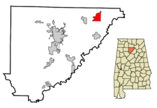
Baileyton is a town in of 619 in northeastern Cullman County, northeast of Cullman and north of Holly Pond, between Wolf Creek and Pan Creek on Alabama State Highway 69.
The community, originally part of Blount County, was settled in 1870 by a group of Georgia farmers led by Robert Bailey, who bought 40 acres from the Louisville & Nashville Railroad on April 16 of that year. Over the next 20 years, several others built farmsteads in the community, raising cotton, corn, potatoes, oats, tobacco, peas, cattle and sheep.
Cullman County was created in 1877. A County Alliance Store opened in the town in the early 1880s, managed by Thomas McClarty. The Baileyton Post Office was established in the store in August 1882. Residents built a schoolhouse in 1885. J. W. Holmes opened a mill in 1889, and Lige Ryan opened a cotton gin. A Dr Gregler began practicing as a physician.
The Town of Baileyton was incorporated on January 31, 1973
Mayors
- Rolfe Burks, 1973–1990
- Paul Bailey, 1990–2008
- Johnny Dyar, 2008–
Geography
The town lies northeast of the city of Cullman along State Route 69, with its municipal boundary reaching northeastward to State Route 67. The town of Fairview lies just to the west along SR 69, and the Joppa community lies opposite SR 67 to the northeast.
According to the U.S. Census Bureau, the town has a total area of Template:Convert, of which Template:Convert is land and Template:Convert, or 1.06%, is water.
Demographics
2000 Census data
As of the census of 2000, there were 684 people, 281 households, and 196 families in the town. The population density was 128.6 people per square mile (49.6/km2). There were 305 housing units at an average density of 57.4 per square mile (22.1/km2). The racial makeup of the town was 99.56% White, 0.29% Native American and 0.15% Asian.
Of the 281 households 32.0% had children under the age of 18 living with them, 56.6% were married couples living together, 8.2% had a female householder with no husband present, and 29.9% were non-families. 27.0% of households were one person and 11.4% were one person aged 65 or older. The average household size was 2.43 and the average family size was 2.93.
The age distribution was 26.6% under the age of 18, 6.1% from 18 to 24, 27.6% from 25 to 44, 26.0% from 45 to 64, and 13.6% 65 or older. The median age was 37 years. For every 100 females, there were 101.2 males. For every 100 females age 18 and over, there were 93.8 males.
The median household income was $31,000 and the median family income was $41,563. Males had a median income of $30,083 versus $20,417 for females. The per capita income for the town was $14,696. About 10.3% of families and 16.6% of the population were below the poverty line, including 21.1% of those under age 18 and 22.5% of those age 65 or over.
| Cullman County | |
|---|---|
| Topics | |
| Cities |
Berlin | Baileyton | Colony | Cullman (seat) | Dodge City | Fairview | Garden City | Good Hope | Hanceville | Holly Pond | South Vinemont | West Point |
References
- Foscue, Virginia O. (1989) Place Names in Alabama. Tuscaloosa: University of Alabama Press. ISBN 081730410X
- "History of Baileyton (2002) Baileyton-al.com - via archive.org
- "Baileyton" () Encyclopedia of Alabama - accessed April 23, 2021