Ensley Five Points West Avenue: Difference between revisions
Jump to navigation
Jump to search
No edit summary |
|||
| Line 1: | Line 1: | ||
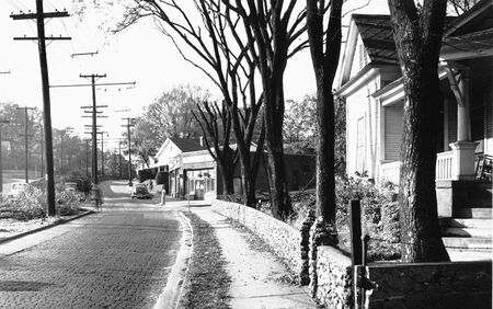
'''Ensley Five Points West Avenue''', | [[File:Hunt-Ensley Ave.jpg|right|thumb|450px|Ensley Avenue, looking north at Avenue U. Photograph by [[O. V. Hunt]].]] | ||
'''Ensley Five Points West Avenue''', formerly '''Ensley Avenue''', is a road which connects [[Five Points West]] at [[Bessemer Road]] ([[U.S. Highway 11]]) in [[Central Park neighborhood|Central Park]], northwest through [[Ensley Highlands]] and [[Tuxedo]] to [[15th Street Ensley]] near the former [[Councill Elementary School]] in the eastern part of [[Ensley neighborhood|Ensley]]. | |||
Before the late 1940s, the avenue was divided with a streetcar track in the median. Where the avenue crested two hills, the tracks ran through cuts supported by retaining walls on either side. During the 1950s those areas were leveled and the entire median paved to create more lanes for traffic. | |||
==Notable addresses (north to south) == | ==Notable addresses (north to south) == | ||
| Line 37: | Line 40: | ||
**** 2310: former location of [[Pate Barber Shop]] (1964) | **** 2310: former location of [[Pate Barber Shop]] (1964) | ||
**** 2312: former location of [[Ensley Avenue Beauty Shop]] (1964) | **** 2312: former location of [[Ensley Avenue Beauty Shop]] (1964) | ||
**** 2318: former location of [[E. R. Maynord]] general contractor (1923) | |||
** east side: | ** east side: | ||
*** 2303: former location of [[Purity Market]] (1964) | *** 2303: former location of [[Purity Market]] (1964) | ||
| Line 60: | Line 64: | ||
*** 2701: former location of [[St John's Episcopal Church]] (1964) | *** 2701: former location of [[St John's Episcopal Church]] (1964) | ||
*** 2715–2717: [[Aletheia House]] apartments, former location of [[Enslean Apartments]] (1964) | *** 2715–2717: [[Aletheia House]] apartments, former location of [[Enslean Apartments]] (1964) | ||
**** 2717: former location of [[H. O. Wray Construction Co.]] (1927) | |||
*** 2725: [[Ensley Highlands Methodist Church]] | *** 2725: [[Ensley Highlands Methodist Church]] | ||
* [[28th Street Ensley]] intersects (east only) | * [[28th Street Ensley]] intersects (east only) | ||
| Line 69: | Line 74: | ||
* [[29th Street Ensley]] (east) / [[Avenue T Ensley]] (north & south) intersect | * [[29th Street Ensley]] (east) / [[Avenue T Ensley]] (north & south) intersect | ||
** east side: | ** east side: | ||
*** 2901: former location of [[29th Street Service Station]] (1927) | |||
*** 2925: former location of [[Ensley Highlands Beauty Shop]] (1964) | *** 2925: former location of [[Ensley Highlands Beauty Shop]] (1964) | ||
*** 2927: former location of [[Bethea Electric Co.]] (1964) | *** 2927: former location of [[Bethea Electric Co.]] (1964) | ||
| Line 76: | Line 82: | ||
* [[Avenue V Ensley]] intersects (east only) | * [[Avenue V Ensley]] intersects (east only) | ||
** west side: | ** west side: | ||
*** 3040: [[Florist & Gift Shop]] | *** 3040: [[Florist & Gift Shop]], former location of [[Paris Beauty Salon]] (1971) | ||
*** 3050–3076: former location of [[Ensley Highland Court Apartments]] (1964) | *** 3050–3076: former location of [[Ensley Highland Court Apartments]] (1964) | ||
** east side: | ** east side: | ||
| Line 101: | Line 107: | ||
*** office building (built 2021), former location of [[Five Points West Exchange Security Bank branch]] (built 1960, demolished 2020), [[First National Bank]] (1971–1983), [[AmSouth Bank]] (1983–2006), [[Regions Bank]] (2006–), [[Schaeffer Eye Center]] (unbuilt 2011) | *** office building (built 2021), former location of [[Five Points West Exchange Security Bank branch]] (built 1960, demolished 2020), [[First National Bank]] (1971–1983), [[AmSouth Bank]] (1983–2006), [[Regions Bank]] (2006–), [[Schaeffer Eye Center]] (unbuilt 2011) | ||
* avenue ends at [[Bessemer Road]] ([[U.S. Highway 11]]). Road continues south as [[Avenue W]] | * avenue ends at [[Bessemer Road]] ([[U.S. Highway 11]]). Road continues south as [[Avenue W]] | ||
==References== | |||
* "[https://cdm16044.contentdm.oclc.org/digital/collection/p4017coll2/id/717/rec/4 Ensley Avenue in 1949. Same Spot in 1960]" (1960) {{BN}} | |||
[[Category:Ensley Five Points West Avenue|*]] | [[Category:Ensley Five Points West Avenue|*]] | ||
Revision as of 11:29, 23 February 2021

Ensley Avenue, looking north at Avenue U. Photograph by O. V. Hunt.
Ensley Five Points West Avenue, formerly Ensley Avenue, is a road which connects Five Points West at Bessemer Road (U.S. Highway 11) in Central Park, northwest through Ensley Highlands and Tuxedo to 15th Street Ensley near the former Councill Elementary School in the eastern part of Ensley.
Before the late 1940s, the avenue was divided with a streetcar track in the median. Where the avenue crested two hills, the tracks ran through cuts supported by retaining walls on either side. During the 1950s those areas were leveled and the entire median paved to create more lanes for traffic.
Notable addresses (north to south)
Ensley
- avenue begins at 15th Street Ensley
- 18th Street Ensley intersects
- west side:
- east side:
- 1829: Trinity AME Zion Church
- 19th Street Ensley intersects
- west side:
- 1900–1910: Erskine Hawkins Park
- 1914: former location of Silver Moon Barber Shop (1964)
- 1920: Belcher-Nixon building
- east side:
- J & J Appliances
- KFC restaurant
- west side:
- 20th Street Ensley (Alabama State Highway 269) intersects ("Tuxedo Junction")
- west side:
- Tuxedo Terrace public housing project (no access)
- east side:
- 2001–2029 (addressed as 1813): Freeway Honda
- west side:
- 20th Place Ensley / Avenue R Ensley formerly intersected
- 21st Street Ensley formerly intersected
- 22nd Street Ensley formerly intersected
- west side:
- 2220: former location of Magic City Laundromat (1964)
- east side:
- 2217: former location of Cann's Souse Co. (1964)
- west side:
- avenue crosses over I-59/20
Ensley Highlands
- Pike Road intersects
- west side:
- 2300–2330 (addressed at 2500): former location of Jim Burke Chevrolet
- 2304: former location of Bay Standard Service Station (1964)
- 2310: former location of Pate Barber Shop (1964)
- 2312: former location of Ensley Avenue Beauty Shop (1964)
- 2318: former location of E. R. Maynord general contractor (1923)
- 2300–2330 (addressed at 2500): former location of Jim Burke Chevrolet
- east side:
- 2303: former location of Purity Market (1964)
- 2307: former location of Birmingham Weatherstripping Co. (1964)
- west side:
- 25th Street Ensley formerly intersected
- west side:
- 2516: former location of Jefferson Apartments (1964)
- east side:
- 2505: former location of Jim Burke Hyundai
- 2509: Enterprise Rent-A-Car
- 2521–2531: former location of Waldrop Leland Gordon Apartments (1964)
- west side:
- 26th Street Ensley intersects
- west side:
- east side:
- 2619 (addressed as 2631): former location of Ensley Highlands Presbyterian Church Frank Moore Cross Educational Building
- 2631 (addressed as 2633): Aletheia House employment training center, former location of Ensley Highlands Presbyterian Church
- Court R Ensley intersects
- 27th Street Ensley intersects (west only)
- west side:
- 2720: former location of M & M Apartments (1964)
- 2730: former location of Little Pre-School Kindergarten & Nursery (Eunice Little 1964)
- east side:
- 2701: former location of St John's Episcopal Church (1964)
- 2715–2717: Aletheia House apartments, former location of Enslean Apartments (1964)
- 2717: former location of H. O. Wray Construction Co. (1927)
- 2725: Ensley Highlands Methodist Church
- west side:
- 28th Street Ensley intersects (east only)
- Avenue S Ensley intersects
- west side:
- 2804–2806: former location of Highland Apartments (1964)
- east side:
- 2805: John's Tax Services, former location of Thomas Winslett (1964)
- west side:
- 29th Street Ensley (east) / Avenue T Ensley (north & south) intersect
- east side:
- 2901: former location of 29th Street Service Station (1927)
- 2925: former location of Ensley Highlands Beauty Shop (1964)
- 2927: former location of Bethea Electric Co. (1964)
- 2931: former location of Segrest Television Rentals (1964)
- east side:
- 30th Place West intersects
- 30th Street Ensley (west) / Avenue U Ensley (east) intersect
- Avenue V Ensley intersects (east only)
- west side:
- 3040: Florist & Gift Shop, former location of Paris Beauty Salon (1971)
- 3050–3076: former location of Ensley Highland Court Apartments (1964)
- east side:
- 3025: WATV-AM / V 94.9 FM
- 3041: Moore's Pharmacy
- 3075: 2200 31st Street Ensley shopping center
- west side:
- 31st Street Ensley intersects
- west side:
- 3100–3106: Chevron gas station / Ensley Seafood, former location of Halcyon Apartments (1964)
- 3112: The Beauty Zone, former location of Thom McAn Shoes (1964)
- 3128: AAA Between Pay
- east side:
- 3101: former location of Canant Quality Cleaners (1964)
- 3103: Lena's East of the Mississippi diner, former location of Crumly's Hickory BBQ (1964–1986), Lena's Ole Hickory Restaurant (1986–2008)
- west side:
Central Park
- Warrior Road intersects
- west side:
- Hollywood Laundry
- Mobil gas station
- east side:
- 3209: former location of A & P supermarket (1964)
- Applebee's restaurant
- office building (built 2021), former location of Five Points West Exchange Security Bank branch (built 1960, demolished 2020), First National Bank (1971–1983), AmSouth Bank (1983–2006), Regions Bank (2006–), Schaeffer Eye Center (unbuilt 2011)
- west side:
- avenue ends at Bessemer Road (U.S. Highway 11). Road continues south as Avenue W