File:Bham homicides 2009.png: Difference between revisions
Jump to navigation
Jump to search
(List of Birmingham homicides in 2008 placed on an ArcGIS Online base map (Sources: Esri, HERE). {{CC Image}} {{Map}}) |
No edit summary |
||
| Line 1: | Line 1: | ||
[[List of Birmingham homicides in | [[List of Birmingham homicides in 2009]] placed on an ArcGIS Online base map (Sources: Esri, HERE). | ||
{{CC Image}} | {{CC Image}} | ||
{{Map}} | {{Map}} | ||
Latest revision as of 16:09, 9 August 2020
List of Birmingham homicides in 2009 placed on an ArcGIS Online base map (Sources: Esri, HERE).
| Image License | |
| This image is licensed under the terms of Creative Commons Attribution Share-Alike v3.0 | |
| Media Type: Map | |
| This is a map or part of a map, the design of which may be protected by copyright. | |
File history
Click on a date/time to view the file as it appeared at that time.
| Date/Time | Thumbnail | Dimensions | User | Comment | |
|---|---|---|---|---|---|
| current | 16:07, 9 August 2020 | 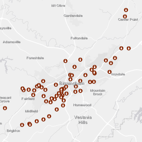 | 480 × 480 (128 KB) | Dystopos (talk | contribs) | List of Birmingham homicides in 2008 placed on an ArcGIS Online base map (Sources: Esri, HERE). {{CC Image}} {{Map}} |
You cannot overwrite this file.
File usage
The following page uses this file: