Five Points South: Difference between revisions
No edit summary |
No edit summary |
||
| (14 intermediate revisions by 2 users not shown) | |||
| Line 1: | Line 1: | ||
:''This article is about the immediate Five Points South area. For the broader neighborhood, see [[Five Points South neighborhood]].'' | :''This article is about the immediate Five Points South area. For the broader neighborhood, see [[Five Points South neighborhood]].'' | ||
[[Image:Five Points South banner.jpg|center|thumb| | [[Image:Five Points South banner.jpg|center|thumb|800px|Five Points South in September 2008, before being painted red.]] | ||
'''Five Points South''' is a district in [[Birmingham]]'s [[Southside]] so named because it is centered on '''Five Points Circle''', an intersection formed into a five-pointed star by the convergence of [[20th Street South]] (in two directions), [[11th Avenue South]], | '''Five Points South''' is a district in [[Birmingham]]'s [[Southside]] so named because it is centered on '''Five Points Circle''', an intersection formed into a five-pointed star by the convergence of [[20th Street South]] (in two directions), [[11th Avenue South]] (in two directions), and [[Magnolia Avenue]]. | ||
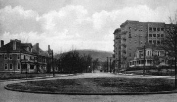
Originally a busy streetcar hub in the then-suburban town of [[Highland]], Five Points Circle has always been an active location and a landmark. Mid-rise apartments grew up alongside boarding homes and stately townhouses sharing easy access to transport. Churches and offices also took advantage of the location. The district's commercial development was | [[Image:Five Points Circle looking south.jpg|left|thumb|350px|Five Points Circle in the 1910s]] | ||
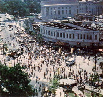
[[Image:5 Pts South 1986.jpg|left|thumb| 350px |Five Points Festival in 1986]] | |||
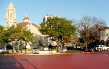
[[Image:Five Points South painted red.jpg|left|thumb| 350px |The circle painted red in November 2008]] | |||
Originally a busy streetcar hub in the then-suburban town of [[Highland]], Five Points Circle has always been an active location and a landmark. Mid-rise apartments grew up alongside boarding homes and stately townhouses sharing easy access to transport. Churches and offices also took advantage of the location. The district's commercial development was pioneered by [[N. W. Henry's]] grocery store in the 1890s, and expanded by the Munger family in the 1920s as automobile traffic began to compete with streetcars. | |||
Traffic congestion at the circle was exacerbated by the growth of "[[Over the Mountain]]" suburban residential communities such as [[Homewood]], [[Mountain Brook]] and [[Vestavia Hills]]. Occasional proposals to improve motor access to [[Shades Valley]] percolated and various committees began studying the alternatives of widening and improving 20th Street and even constructing a [[Red Mountain tunnel|tunnel through Red Mountain]]. Sergeant [[Ben Robinson]] of the city's traffic engineering division drew up a proposal for converting the intersection into a true traffic circle. Because the city itself had "no plans for instituting the idea," he sent it to the [[Red Mountain Tunnel Committee]] for their consideration. | |||
During the middle of the 20th century the Southside area, with Five Points South at its heart, became known as a refuge for bohemian living. Students and faculty from the emerging [[UAB]] campus nearby helped fuel a "golden era" of counterculture. Locally-owned businesses came and went, a few becoming institutions in the neighborhood while more and more mainstream shoppers headed "[[over the mountain]]" to spend their money. | During the middle of the 20th century the Southside area, with Five Points South at its heart, became known as a refuge for bohemian living. Students and faculty from the emerging [[UAB]] campus nearby helped fuel a "golden era" of counterculture. Locally-owned businesses came and went, a few becoming institutions in the neighborhood while more and more mainstream shoppers headed "[[over the mountain]]" to spend their money. | ||
By the 1970s the district was moribund. Its architecture, by then "historic", was recognized as an asset and area residents began laying the groundwork for protecting it | By the 1970s the district was moribund. Its architecture, by then "historic", was recognized as an asset and area residents began laying the groundwork for protecting it as part of a designated "Commercial Revitalization District". Landscape architects [[Blalock, Barbour & Cooper]] were commissioned to create a public space improvement plan. Over the next decades a series of important development transformed the area into Birmingham's premier entertainment district with fine dining and numerous nightclubs. | ||
More recently, with the district has been described as a place that changes character depending on the time of day. During the day and early evening the area's dining options attract crowds of office workers and visitors. On weekends daytime churchgoers yield to evening diners and clubgoers, while late at night the streets are filled with teenagers cruising and packing into dance clubs. Overt panhandling, [[Crime in Birmingham|criminal activity]] and a generally threatening atmosphere have | More recently, with the district has been described as a place that changes character depending on the time of day. During the day and early evening the area's dining options attract crowds of office workers and visitors. On weekends daytime churchgoers yield to evening diners and clubgoers, while late at night the streets are filled with teenagers cruising and packing into dance clubs. In the late 1980s, the area around the fountain was frequented at night by "punks and skinheads". Overt panhandling, [[Crime in Birmingham|criminal activity]] and a generally threatening atmosphere have continued to be widely reported, leading some to frequent other areas perceived as safer. | ||
In order to combat those factors, the [[Five Points South Merchants Association]] has campaigned to draw people back to the district and lobbied the city to improve street and sidewalk maintenance and security. Those efforts were drawn into sharp relief early on the morning of [[July 5]], [[2008]]. Just hours after a block party planned by the association welcomed families to view the [[Thunder on the Mountain]] fireworks display from Five Points South a nightclub brawl at [[Banana Joe's]] spilled out into the parking lot and two men were [[List of Birmingham homicides in 2008|killed]] by gunfire. | In order to combat those factors, the [[Five Points South Merchants Association]] has campaigned to draw people back to the district and lobbied the city to improve street and sidewalk maintenance and security. Those efforts were drawn into sharp relief early on the morning of [[July 5]], [[2008]]. Just hours after a block party planned by the association welcomed families to view the [[Thunder on the Mountain]] fireworks display from Five Points South a nightclub brawl at [[Banana Joe's]] spilled out into the parking lot and two men were [[List of Birmingham homicides in 2008|killed]] by gunfire. | ||
| Line 17: | Line 21: | ||
==Five Points South landmarks== | ==Five Points South landmarks== | ||
* [[Highlands United Methodist Church]] (built 1909) | |||
* [[Highlands United Methodist Church]] | * [[Studio Arts Building]] (built 1910, demolished 1986, rebuilt 1994) | ||
* [[ | * [[Spanish Stores]] (built 1926) | ||
* [[ | * [[Shepherd-Sloss building]] (built 1928) | ||
* [[Shepherd-Sloss building]] | * [[Munger Building]] (built 1929) | ||
* [[ | * [[Ware Building]] (built 1930) | ||
* [[ | * [[Medical Arts Building]] (built 1931) | ||
* [[ | * [[Brother Bryan statue]], (dedicated 1934, removed 1966, returned 1983) | ||
* [[Pickwick Plaza]] (built 1987) | |||
* [[Storyteller fountain]] (dedicated 1992) | |||
==References== | ==References== | ||
{{locate | lat = 33.50065 | lon=-86.79629 |type=k|zoom=17}} | {{locate | lat = 33.50065 | lon=-86.79629 |type=k|zoom=17}} | ||
* "[http://bplonline.cdmhost.com/digital/collection/p4017coll2/id/2039/rec/12 Five Points, S, traffic easing plan considered]" (c. 1955) newspaper clipping - via {{BPLDC}} | |||
* {{Burkhardt-1982}} | * {{Burkhardt-1982}} | ||
* Archibald, John (November 20, 2008) "Red circle makes for hue & cry." | * Morris, Philip (1988) "[http://content.lib.auburn.edu/cdm/singleitem/collection/design/id/25/rec/3 Urban Design: Everybody's Business: Birmingham]" ''Design Alabama'', Vol. 1, No. 2, pp. 10-11 | ||
* DeButts, Jimmy (November 21, 2008) "Five Points merchants optimistic on renovation." | * Chappell, Steven Eric (July 25, 1989) "[https://www.mhsl.uab.edu/kscope/1989/24.pdf The violence at Five Points South]" ''Kaleidoscope'', Vol. 37, No. 7, p. 1 | ||
* Archibald, John (November 20, 2008) "Red circle makes for hue & cry." {{BN}} | |||
* DeButts, Jimmy (November 21, 2008) "Five Points merchants optimistic on renovation." {{BBJ}} | |||
* Kwon, Wade (November 1, 2010) "Five Points South gets a new look for fall." ''Magic City Post'' | * Kwon, Wade (November 1, 2010) "Five Points South gets a new look for fall." ''Magic City Post'' | ||
* Edgemon, Erin (October 12, 2018) "Birmingham’s Five Points South is cool again: Here’s why." {{BN}} | |||
[[Category:Five Points South|*]] | [[Category:Five Points South|*]] | ||
Latest revision as of 10:44, 18 February 2023
- This article is about the immediate Five Points South area. For the broader neighborhood, see Five Points South neighborhood.
Five Points South is a district in Birmingham's Southside so named because it is centered on Five Points Circle, an intersection formed into a five-pointed star by the convergence of 20th Street South (in two directions), 11th Avenue South (in two directions), and Magnolia Avenue.
Originally a busy streetcar hub in the then-suburban town of Highland, Five Points Circle has always been an active location and a landmark. Mid-rise apartments grew up alongside boarding homes and stately townhouses sharing easy access to transport. Churches and offices also took advantage of the location. The district's commercial development was pioneered by N. W. Henry's grocery store in the 1890s, and expanded by the Munger family in the 1920s as automobile traffic began to compete with streetcars.
Traffic congestion at the circle was exacerbated by the growth of "Over the Mountain" suburban residential communities such as Homewood, Mountain Brook and Vestavia Hills. Occasional proposals to improve motor access to Shades Valley percolated and various committees began studying the alternatives of widening and improving 20th Street and even constructing a tunnel through Red Mountain. Sergeant Ben Robinson of the city's traffic engineering division drew up a proposal for converting the intersection into a true traffic circle. Because the city itself had "no plans for instituting the idea," he sent it to the Red Mountain Tunnel Committee for their consideration.
During the middle of the 20th century the Southside area, with Five Points South at its heart, became known as a refuge for bohemian living. Students and faculty from the emerging UAB campus nearby helped fuel a "golden era" of counterculture. Locally-owned businesses came and went, a few becoming institutions in the neighborhood while more and more mainstream shoppers headed "over the mountain" to spend their money.
By the 1970s the district was moribund. Its architecture, by then "historic", was recognized as an asset and area residents began laying the groundwork for protecting it as part of a designated "Commercial Revitalization District". Landscape architects Blalock, Barbour & Cooper were commissioned to create a public space improvement plan. Over the next decades a series of important development transformed the area into Birmingham's premier entertainment district with fine dining and numerous nightclubs.
More recently, with the district has been described as a place that changes character depending on the time of day. During the day and early evening the area's dining options attract crowds of office workers and visitors. On weekends daytime churchgoers yield to evening diners and clubgoers, while late at night the streets are filled with teenagers cruising and packing into dance clubs. In the late 1980s, the area around the fountain was frequented at night by "punks and skinheads". Overt panhandling, criminal activity and a generally threatening atmosphere have continued to be widely reported, leading some to frequent other areas perceived as safer.
In order to combat those factors, the Five Points South Merchants Association has campaigned to draw people back to the district and lobbied the city to improve street and sidewalk maintenance and security. Those efforts were drawn into sharp relief early on the morning of July 5, 2008. Just hours after a block party planned by the association welcomed families to view the Thunder on the Mountain fireworks display from Five Points South a nightclub brawl at Banana Joe's spilled out into the parking lot and two men were killed by gunfire.
In November 2008 the city repaved all the streets in the immediate vicinity of Five Points South, repainted traffic signals and lampposts in the district, and covered the Five Points circle and patterned concrete sidewalks around it with bright red paint as part of an effort to dress up the area in advance of the annual PapaJohns.com Bowl. A UAB Blazers logo was painted on the circle in preparation for the 2010 homecoming game on November 6.
Five Points South landmarks
- Highlands United Methodist Church (built 1909)
- Studio Arts Building (built 1910, demolished 1986, rebuilt 1994)
- Spanish Stores (built 1926)
- Shepherd-Sloss building (built 1928)
- Munger Building (built 1929)
- Ware Building (built 1930)
- Medical Arts Building (built 1931)
- Brother Bryan statue, (dedicated 1934, removed 1966, returned 1983)
- Pickwick Plaza (built 1987)
- Storyteller fountain (dedicated 1992)
References
- "Five Points, S, traffic easing plan considered" (c. 1955) newspaper clipping - via Birmingham Public Library Digital Collections
- Burkhardt, Ann McQuorquodale and Alice Meriwether Bowsher (November 1982) "Town Within a City: The Five Points South Neighborhood 1880-1930." Journal of the Birmingham Historical Society. Vol. 7, Nos. 3-4
- Morris, Philip (1988) "Urban Design: Everybody's Business: Birmingham" Design Alabama, Vol. 1, No. 2, pp. 10-11
- Chappell, Steven Eric (July 25, 1989) "The violence at Five Points South" Kaleidoscope, Vol. 37, No. 7, p. 1
- Archibald, John (November 20, 2008) "Red circle makes for hue & cry." The Birmingham News
- DeButts, Jimmy (November 21, 2008) "Five Points merchants optimistic on renovation." Birmingham Business Journal
- Kwon, Wade (November 1, 2010) "Five Points South gets a new look for fall." Magic City Post
- Edgemon, Erin (October 12, 2018) "Birmingham’s Five Points South is cool again: Here’s why." The Birmingham News


