Red Mountain cut: Difference between revisions
No edit summary |
No edit summary |
||
| (10 intermediate revisions by 2 users not shown) | |||
| Line 5: | Line 5: | ||
[[Image:Red Mountain cut rendering.jpg|left|thumb|350px|1960 rendering of the proposed cut]] | [[Image:Red Mountain cut rendering.jpg|left|thumb|350px|1960 rendering of the proposed cut]] | ||
[[Image:Red Mtn cut 1969.jpg|left|thumb|350px|1969 photo of the east side of the cut]] | |||
The expressway was planned as a six-lane limited-access highway to accommodate anticipated traffic demand for [[1980]] (29,400 cars and 990 heavy trucks per day). The engineers evaluated a total of 23 possible routes across the mountain, which they narrowed down to six preferred candidates, three in tunnels and three exposed as cuts. All the evaluated options used [[26th Street South]] as the starting point. The route finally selected ("Cut Route D") was the one projected to involve the least cost in purchasing right-of-way and executing construction work. The planners also considered the route's "s-curve" to have aesthetic appeal. | The expressway was planned as a six-lane limited-access highway to accommodate anticipated traffic demand for [[1980]] (29,400 cars and 990 heavy trucks per day). The engineers evaluated a total of 23 possible routes across the mountain, which they narrowed down to six preferred candidates, three in tunnels and three exposed as cuts. All the evaluated options used [[26th Street South]] as the starting point. The route finally selected ("Cut Route D") was the one projected to involve the least cost in purchasing right-of-way and executing construction work. The planners also considered the route's "s-curve" to have aesthetic appeal. | ||
Digging and grading took 7 years, from [[1962]] to [[1969]], and the cut was opened to traffic in [[1970]]. | Digging and grading took 7 years, from [[1962]] to [[1969]], and the cut was opened to traffic in [[1970]]. The removal of 2 million cubic yards of the ridge of [[Red Mountain]] exposed over 190 million years of geologic strata dating to over 500 million years ago. The Ordovician, Silurian, Devonian and Mississippian geologic periods are visible in the cut. Special features include caves, volcanic ash layers, the Red Mountain fault line, prehistoric reefs and beaches, fossils and fossil tracks. Significantly, the cut reveals the cross-section of the [[Red Mountain ore|red ore]] seam that spurred Birmingham's development and a layer containing fossils of a unique Silurian [[Llandovacaste birminghamensis|trilobite species]]. | ||
A group of geologists associated with [[UAB]] visited the newly-exposed rock strata during the late stages of construction, measuring geologic layers. When informed that the surface was due to be sealed with a layer of concrete in a matter of days, one of the scientists resorted to lying down in front of the concrete truck to stall their progress. An emergency appeal to [[Governor of Alabama|Governor]] [[George Wallace]] led to a reversal of plans to cover the cut face. | |||
A new city-owned science museum, The [[Red Mountain Museum]], was opened on the slope adjacent to the cut in February [[1978]]<!--note, News article says September 14, 1977-->. The impetus for the museum grew out of the protests of geologists from the Geological Survey of Alabama, [[Birmingham-Southern College]], and the Alabama Geological Society, who, with the support of the [[Linn-Henley Charitable Trust]], convinced the Highway department to stop spraying concrete over the exposed rock strata. Museum-sponsored paleontologists recovered a large collection of fossils which now form the core of a valuable collection of Alabama fossils held by the [[McWane Science Center]]. Interpretive signage was installed along one of the eastern terraces of the cut and guardrails and fencing installed to allow museum visitors to inspect the exposed rock close-up. It is one of only three such "interpretive cuts" in the United States. The others are along Interstate 70 near Denver, Colorado and Interstate 68 in western Maryland. | A new city-owned science museum, The [[Red Mountain Museum]], was opened on the slope adjacent to the cut in February [[1978]]<!--note, News article says September 14, 1977-->. The impetus for the museum grew out of the protests of geologists from the Geological Survey of Alabama, [[Birmingham-Southern College]], and the Alabama Geological Society, who, with the support of the [[Linn-Henley Charitable Trust]], convinced the Highway department to stop spraying concrete over the exposed rock strata. Museum-sponsored paleontologists recovered a large collection of fossils which now form the core of a valuable collection of Alabama fossils held by the [[McWane Science Center]]. Interpretive signage was installed along one of the eastern terraces of the cut and guardrails and fencing installed to allow museum visitors to inspect the exposed rock close-up. It is one of only three such "interpretive cuts" in the United States. The others are along Interstate 70 near Denver, Colorado and Interstate 68 in western Maryland. | ||
[[Image:Red Mountain cut.jpg|thumb|left|350px|The Red Mountain cut from the south | [[Image:Red Mountain cut.jpg|thumb|left|350px|The Red Mountain cut from the south in 2007]] | ||
In [[1991]], the Red Mountain Museum partnered with a nearby children's science museum, The [[Discovery Place]], to form "Discovery 2000". Together they moved to downtown Birmingham in [[1998]] and became the [[McWane Science Center]]. | In [[1991]], the Red Mountain Museum partnered with a nearby children's science museum, The [[Discovery Place]], to form "Discovery 2000". Together they moved to downtown Birmingham in [[1998]] and became the [[McWane Science Center]]. | ||
In [[1987]] the Red Mountain Expressway Cut was granted [[National Natural Landmark]] status by the [[National Park Service]]. Deemed unsafe because of the potential for rockslides, the interpretive trail has since been closed to the public. | In [[1987]] the Red Mountain Expressway Cut was granted [[National Natural Landmark]] status by the [[National Park Service]]. Deemed unsafe because of the potential for rockslides, the interpretive trail has since been closed to the public. | ||
In 2006 McWane president [[Tim Ritchie]] and staff paleontologist [[James Lamb]] discussed the possibility of selling the former Red Mountain Museum property, but keeping a public access to the walkway, which could be renovated and reopened. In [[2007]] the City of [[Birmingham]] reached an agreement with the [[Dominican Sisters of St Cecilia Congregation]] to purchase the former Red Mountain Museum for $606,632 for use as parking for its [[ | In 2006 McWane president [[Tim Ritchie]] and staff paleontologist [[James Lamb]] discussed the possibility of selling the former Red Mountain Museum property, but keeping a public access to the walkway, which could be renovated and reopened. In [[2007]] the City of [[Birmingham]] reached an agreement with the [[Dominican Sisters of St Cecilia Congregation]] to purchase the former Red Mountain Museum for $606,632 for use as parking for its [[Saint Rose Academy]]. The city retained the small neighborhood park adjacent to the museum, and the locked access to the Red Mountain cut walkway. Proceeds from the sale were directed to the McWane Science Center. | ||
In [[2022]] [[EBSCO]] CEO [[Bryson Stephens]] founded a non-profit [[Red Mountain Cut Foundation]] to promote restoration of the interpretive path as a recreational path and visitor attraction. The foundation backed an [[Alabama Department of Transportation]] project to remove vegetation from the sides of the cut in advance of the [[2022 World Games]]. | |||
{{Start box}} | |||
{{Location E-W box|title=[[Red Mountain]] passes|west=[[Lone Pine Gap]]|east=[[Brown's Gap]]}} | |||
{{End box}} | |||
==References== | ==References== | ||
* Beiman, Irving (December 21, 1960) "[http://www.birminghamrewound.com/features/Expressway-1(12-60).jpg 11½ million Red Mtn. expressway cut urged]" | * Beiman, Irving (December 21, 1960) "[http://www.birminghamrewound.com/features/Expressway-1(12-60).jpg 11½ million Red Mtn. expressway cut urged]" {{BN}} - via [[Birmingham Rewound]] | ||
* White, Marjorie Longenecker (1981) "Red Mountain Museum" in ''The Birmingham District: An Industrial History and Guide'' Birmingham: Birmingham Historical Society. p. 222 | * White, Marjorie Longenecker (1981) "Red Mountain Museum" in ''The Birmingham District: An Industrial History and Guide'' Birmingham: Birmingham Historical Society. p. 222 | ||
* Hickerson, Patrick. (April 23, 2006) "McWane eyes Red Mountain path revival: Cut near old museum site puts rock history on display." | * Hickerson, Patrick. (April 23, 2006) "McWane eyes Red Mountain path revival: Cut near old museum site puts rock history on display." {{BN}} | ||
* Coman, Victoria L. (May 15, 2007) "Vote on selling museum site to St. Cecilia nuns expected." ''Birmingham | * Coman, Victoria L. (May 15, 2007) "Vote on selling museum site to St. Cecilia nuns expected." {{BN}} | ||
* Kelley, David (n.d.) "[http://www.magiccityweekend.com/history-of-birmingham-the-cut-in-red-mountain/?fbclid=IwAR29_Qw6gABYNOgHQUAX51VyxQfzVeW21ksQB8GXJZvHODI5ndVeBJ0bL90 History of Birmingham – The Cut in Red Mountain]" Magic City Weekend / WBRC - accessed December 3, 2018 | |||
* Watson, Nathan (August 23, 2022) "How you can help restore the Red Mountain Cut Geologic Walkway." {{BNow}} | |||
* Stephens, Bryson (October 10, 2023) "[https://comebacktown.com/2023/10/10/a-one-of-a-kind-world-class-asset-could-change-the-face-of-birmingham/ A One-of-a-kind World-Class Asset Could Change the Face of Birmingham]." ''Comeback Town'' | |||
== External links == | |||
* [https://redmountaincut.org/ Red Mountain Cut Foundation] website | |||
* [http://lcweb2.loc.gov/cgi-bin/query/S?pp/hh:@field(TITLE+@od1(Red+Mountain+Cut+National+Natural+Landmark,+U+S++280+at+Red+Mountain,+Birmingham,+Jefferson+County,+AL)) Library of Congress] page about the Red Mountain Expressway Cut. | |||
[[Category:Red Mountain|Cut]] | [[Category:Red Mountain|Cut]] | ||
Latest revision as of 11:38, 27 October 2023
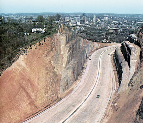
The Red Mountain cut is a 210-foot-deep, 1,640-foot-long highway cut created through Red Mountain for the Red Mountain expressway, an extension of Highway 31 and Highway 280 into downtown Birmingham.
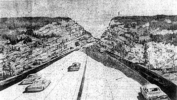
The project represented the latest in a series of proposals to create a Red Mountain Tunnel through the ridge to connect Birmingham to Homewood and other new residential areas to the South. The recommendation to use a road cut rather than a tunnel was made by Harland Bartholomew and other consultants in their 1960 report to the Birmingham Downtown Improvement Association and the Jefferson County Commission. The cities of Birmingham, Homewood, Mountain Brook and Vestavia Hills subsidized the study along with the County Commission and Alabama State Highway Department.
The expressway was planned as a six-lane limited-access highway to accommodate anticipated traffic demand for 1980 (29,400 cars and 990 heavy trucks per day). The engineers evaluated a total of 23 possible routes across the mountain, which they narrowed down to six preferred candidates, three in tunnels and three exposed as cuts. All the evaluated options used 26th Street South as the starting point. The route finally selected ("Cut Route D") was the one projected to involve the least cost in purchasing right-of-way and executing construction work. The planners also considered the route's "s-curve" to have aesthetic appeal.
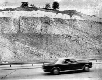
Digging and grading took 7 years, from 1962 to 1969, and the cut was opened to traffic in 1970. The removal of 2 million cubic yards of the ridge of Red Mountain exposed over 190 million years of geologic strata dating to over 500 million years ago. The Ordovician, Silurian, Devonian and Mississippian geologic periods are visible in the cut. Special features include caves, volcanic ash layers, the Red Mountain fault line, prehistoric reefs and beaches, fossils and fossil tracks. Significantly, the cut reveals the cross-section of the red ore seam that spurred Birmingham's development and a layer containing fossils of a unique Silurian trilobite species.
A group of geologists associated with UAB visited the newly-exposed rock strata during the late stages of construction, measuring geologic layers. When informed that the surface was due to be sealed with a layer of concrete in a matter of days, one of the scientists resorted to lying down in front of the concrete truck to stall their progress. An emergency appeal to Governor George Wallace led to a reversal of plans to cover the cut face.
A new city-owned science museum, The Red Mountain Museum, was opened on the slope adjacent to the cut in February 1978. The impetus for the museum grew out of the protests of geologists from the Geological Survey of Alabama, Birmingham-Southern College, and the Alabama Geological Society, who, with the support of the Linn-Henley Charitable Trust, convinced the Highway department to stop spraying concrete over the exposed rock strata. Museum-sponsored paleontologists recovered a large collection of fossils which now form the core of a valuable collection of Alabama fossils held by the McWane Science Center. Interpretive signage was installed along one of the eastern terraces of the cut and guardrails and fencing installed to allow museum visitors to inspect the exposed rock close-up. It is one of only three such "interpretive cuts" in the United States. The others are along Interstate 70 near Denver, Colorado and Interstate 68 in western Maryland.
In 1991, the Red Mountain Museum partnered with a nearby children's science museum, The Discovery Place, to form "Discovery 2000". Together they moved to downtown Birmingham in 1998 and became the McWane Science Center.
In 1987 the Red Mountain Expressway Cut was granted National Natural Landmark status by the National Park Service. Deemed unsafe because of the potential for rockslides, the interpretive trail has since been closed to the public.
In 2006 McWane president Tim Ritchie and staff paleontologist James Lamb discussed the possibility of selling the former Red Mountain Museum property, but keeping a public access to the walkway, which could be renovated and reopened. In 2007 the City of Birmingham reached an agreement with the Dominican Sisters of St Cecilia Congregation to purchase the former Red Mountain Museum for $606,632 for use as parking for its Saint Rose Academy. The city retained the small neighborhood park adjacent to the museum, and the locked access to the Red Mountain cut walkway. Proceeds from the sale were directed to the McWane Science Center.
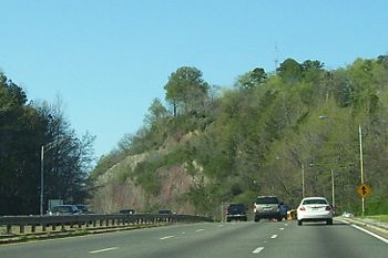
In 2022 EBSCO CEO Bryson Stephens founded a non-profit Red Mountain Cut Foundation to promote restoration of the interpretive path as a recreational path and visitor attraction. The foundation backed an Alabama Department of Transportation project to remove vegetation from the sides of the cut in advance of the 2022 World Games.
| To the west: Lone Pine Gap |
Red Mountain passes Red Mountain cut |
To the east: Brown's Gap |
References
- Beiman, Irving (December 21, 1960) "11½ million Red Mtn. expressway cut urged" The Birmingham News - via Birmingham Rewound
- White, Marjorie Longenecker (1981) "Red Mountain Museum" in The Birmingham District: An Industrial History and Guide Birmingham: Birmingham Historical Society. p. 222
- Hickerson, Patrick. (April 23, 2006) "McWane eyes Red Mountain path revival: Cut near old museum site puts rock history on display." The Birmingham News
- Coman, Victoria L. (May 15, 2007) "Vote on selling museum site to St. Cecilia nuns expected." The Birmingham News
- Kelley, David (n.d.) "History of Birmingham – The Cut in Red Mountain" Magic City Weekend / WBRC - accessed December 3, 2018
- Watson, Nathan (August 23, 2022) "How you can help restore the Red Mountain Cut Geologic Walkway." Bham Now
- Stephens, Bryson (October 10, 2023) "A One-of-a-kind World-Class Asset Could Change the Face of Birmingham." Comeback Town
External links
- Red Mountain Cut Foundation website
- Library of Congress page about the Red Mountain Expressway Cut.


