6th Avenue South: Difference between revisions
(added photo) |
|||
| Line 86: | Line 86: | ||
** 1601: [[Children's Hospital]] | ** 1601: [[Children's Hospital]] | ||
** 1616: [[Benjamin Russell Hospital for Children]], former site of [[Midtown Center]] | ** 1616: [[Benjamin Russell Hospital for Children]], former site of [[Midtown Center]] | ||
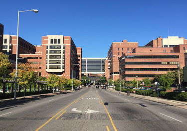
[[Image:6th_Avenue_South_in_the_UAB_Medical_Center.jpg|right|thumb|375px|6th Avenue South looking east from 17th Street South]] | |||
* [[17th Street South]] intersection (north only) | * [[17th Street South]] intersection (north only) | ||
** 1700: [[UAB Women and Infants Center]] | ** 1700: [[UAB Women and Infants Center]] | ||
| Line 93: | Line 94: | ||
** 1719: [[Civitan International Research Center]] | ** 1719: [[Civitan International Research Center]] | ||
* [[18th Street South]] intersection | * [[18th Street South]] intersection | ||
** 1800: [[UAB | ** 1800: [[UAB North Pavilion]] | ||
** 1813: [[UAB Medical Education Building]], [[Russell Ambulatory Center]] | ** 1813: [[UAB Medical Education Building]], [[Russell Ambulatory Center]] | ||
** 1824: [[Wallace Tumor Institute]] | ** 1824: [[Wallace Tumor Institute]] | ||
Revision as of 17:47, 3 October 2016
Sixth Avenue South (originally Avenue F) is a major east-west corridor in downtown Birmingham. It is the farthest westward-reaching avenue on downtown Birmingham's south side, the westernmost eight blocks (west of Center Street) being designated 6th Avenue Southwest and ending at the entrance to Elmwood Cemetery on Martin Luther King, Jr Drive. The easternmost segment ends at 85th Street in South East Lake.
The section of 6th Avenue west of Interstate 65 divides North Titusville from South Titusville. Between 34th and 37th Street South it divides the Southside neighborhood from Forest Park-South Avondale.
Sixth Avenue is continuous from Martin Luther King, Jr Drive to 39th Street South, passing through the center of the Titusville community, under I-65, through the northern edge of the UAB campus, and under the Elton B. Stephens Expressway. From Martin Luther King, Jr Drive to 37th Street, it is a four- or five-lane road. The rest is a two-lane residential road.
The residential portion is first interrupted between 40th and 42nd Streets for Avondale Park, ending again at 46th Alley. Beyond that, there are several discontinuous sections through East Avondale, Crestwood North, Oak Ridge Park, East Lake, and South East Lake, none of which intersect with any major thoroughfares.
Notable locations
- For an alphabetical list of locations, see the 6th Avenue South category.
North & South Titusville neighborhoods
6th Avenue Southwest
- Martin Luther King, Jr Drive intersection (road terminus, but leads directly into Elmwood Cemetery)
- 344: Bolin-Reeves Florist
- 320: U-Haul
- 309: Sixth Avenue Tire
- 308: Clark Memorials
- 249: Wiggins & Seay Fabrics
- 231: Suit Warehouse
- 222: Commercial Printing Company
- 201: former location of Goldwire Texaco, Christy's Texaco (-2015)
- Goldwire Street Southwest intersection
- 141: former location of Mayfield Cleaners (1969)
- 137: Sixth Avenue Meat Market
- 102: Smith & Gaston Funeral Services
- 100: Halls Birmingham Wholesale Florist
- 20: Westminster Presbyterian Church
- 2: Titusville Library
- Center Street South intersection
6th Avenue South
- Center Street South intersection
- 45: Chris McNair Studios
- 55: Leonard's Upholstery & Furniture Repair
- 74: Exxon station
- 1st Street South intersection
- 2nd Street South intersection
- 200: Family Dollar, former location of Butters restaurant (1980s)
- 216: Hollywood Beauty Shop
- 301: Automotive South
- 326: former location of R&S Supermarket (-2015)
- 334: EVision, LLC
- 422: A & S Bail Bond Company
- 500: Memorial Park
- 501: Birmingham City Jail
- 6th Street South intersection
- AMM Corporation
- 619: former location of William Conley restaurant (1928)
- 8th Street South intersection
- 801: UAB Facilities Administration Building
- 802: UAB internal operations and storage (2016-), former location of EBSCO Media offices
- 9th Street South intersection (south only)/I-65 South west-bound off ramp
- Passes under Interstate 65
Five Points South neighborhood (UAB campus)
- Passes under Interstate 65
- 11th Street South intersection
- Birmingham Fire Station No. 2
- 1100: proposed site of UAB Stadium
- 1101: UAB Practice Field
- 12th Street South intersection (north only)
- 1200: former Food Fair super market
- 1201: Wallace Physical Fitness Complex
- 1205: Ullman Boiler Building
- 13th Street South intersection
- 1300: UAB Lot 15N
- 1301: Bartow Arena
- 1330: former location of L. K. Harris grocery (1925)
- 14th Street South intersection
- 1400: Guy M. Tate Building (Jefferson County Health Department)
- 1401: Cooper Green Parking Deck
- 1408: former location of V. Gilb & Son brass foundry (1904)
- 1426: former location of Presto Cleaning & Pressing Co. (1925)
- 15th Street South intersection (north only)
- 1500: UAB Obstetrics Special Care
- 1515: Cooper Green Mercy Hospital
- 1524: Burger King
- 16th Street South intersection
- 1600: Children's Harbor
- 1601: Children's Hospital
- 1616: Benjamin Russell Hospital for Children, former site of Midtown Center
- 17th Street South intersection (north only)
- 1700: UAB Women and Infants Center
- 1701: former location of M. C. Varavella grocer & butcher (1925)
- 1713: UAB Center For Psychiatric Medicine
- 1717: Spain Rehabilitation Center
- 1719: Civitan International Research Center
- 18th Street South intersection
- 19th Street South intersection
- 1900: Hillman Hospital
- 1915: UAB Medical Center North Wing
- 1960: UAB 6th Avenue Parking Deck
- 20th Street South intersection
- 2000: Kirklin Clinic, former location of Southside Baptist Church (-1906), St Elias Maronite Church
- 2008: former location of Merita Bakery
- 2009: former location of The Old Cottage antiques (1946)
- 21st Street South intersection
- 2100: Kirklin Clinic Parking Deck, former location of First Christian Church
- 2101: Regions Bank drive-through
- 2109: Dunkin' Donuts (opened February 18, 2011, former location of Black Dog Pawn Shop and Domino's Pizza)
- 2124: former location of Brownell Motors
- 500 Building
- 2133: Harris Transfer Company warehouse, Fish Market Restaurant
- 22nd Street South intersection
Southside neighborhood
- 22nd Street South intersection
- 2200: Speedy Print building (former location of Uncle Tom's Bar-B-Q)
- 2203: Alabama Typewriter Company
- 2208: Iron City Grill
- 2222: former location of Ernest Woods Pontiac (1955)
- 2233: Backstage Florist & Gifts
- 23rd Street South intersection
- 2325: former location of the Ozo-Olo Company
- 2328: Albert B. Stapp Company Service Station
- 2330: former location of Courtney's Restaurant
- 2331: Gary Chapin's Auto Clinic, former location of Nehi Bottling Company
- 24th Street South intersection
- 2401: Wells Fargo Southside office (1955-)
- 2428: Bresco, former location of Liberty Motors
- 2434: Foreign Car Body Shop
- 25th Street South intersection
- 2500: Full Moon BBQ
- 2501-2515: Mack Truck Garage (built 1924)
- 2501: Events at Haven (2016-)
- 2515: DataPerk offices (2016-)
- 2516: Service Construction Supply
- Passes under Elton B. Stephens Expressway
- 2609: East End Baptist Church
- 2620: Bradley & Bradley Body Shop
- 27th Street South intersection
- 2700: Peal Substation Services, former location of Gaines Grocery Co.
- 2702: former location of Carroll, Andrews & Co. painters, paperhanger & decorators (1923-1925)
- 28th Street South intersection
- 2800: former location of J. & L. Market grocery store (1962)
- 2801: Loretta Goodwin Gallery
- 2817: Pilgrim Church
- 2820: J. F. Day & Company
- 2830: Matt Jones Gallery
- 2900: Medical Imaging Systems
- 29th Street South intersection
- 2901: Benjamin Worthington's peach orchard
- 2912: Plant Odyssey
- 30th Street South intersection
- 3000: former location of Joe Salamone grocery store (1962)
- 3001: former site of Trinity Methodist Church (Southside)
- 3010: Clutch & Brake Specialty Company
- 3015: Rozar's Auto Paint Supply
- 3022: Brannon Electric Motor Company
- 3025: Daniel Day Gallery/Dream Mecca
- 3027: 365 Incorporated
- 3029: Autobahn South
- 31st Street South intersection
- 3101: Birmingham Printing & Publishing
- 3130: Naia Corporation
- former location of Richard Hawes' residence
- 32nd Street South intersection
- 3200: Tire Engineers
- 3201: BBVA Compass Operations Center
- 3222: Pet Wellness Center
- 33rd Street South intersection (north only)
- 34th Street South intersection
Southside neighborhood/Forest Park-South Avondale neighborhood

- 34th Street South intersection
- former location of William Pullen's grave
- 3400: MDM Design Studio
- 3404: Prantl Printing Company
- 3410: BLP Mobile Paint Center
- 3416: former location of Delta Pawn
- 3421: Stewart's Imports & Antiques, Delta Pawn, former location of Church & Stagg
- 3425: Jimmy's Hot Dogs & Burgers
- 3430: Oscar Quick Stop, Citgo gas station
- 35th Street South intersection
- 3500: former location of Doug Willey Pontiac/Williamson-Willey Pontiac
- 3505: former location of A-One Restaurant and Lounge
- 3507: Sneaky Pete's
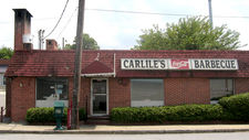
- 3511: Carlile's Barbecue
- 36th Street South intersection
- 3601: Opera Birmingham office
- 3621: Alabama Symphony Orchestra office
- 3630: Derby Bar & Grill
- 37th Street South intersection
Forest Park-South Avondale neighborhood
- 37th Street South intersection
- 3700: DSR Inc
- 3701: Alabama Oriental Medical Arts
- 38th Street South intersection
- 39th Street South intersection (road terminus at Baha'i Center)
- 42nd Street South intersection (road terminus Avondale Park)
- 43rd Street South intersection
- 44th Street South intersection
- 44th Place South intersection
- 45th Street South intersection
- 46th Street South intersections (road does not align)
- 46th Alley South intersection (road terminus)
Crestwood North neighborhood
- 5405: former location of Woodlawn Infirmary
