20th Street North: Difference between revisions
No edit summary |
|||
| Line 40: | Line 40: | ||
** 9: [[Taylor Building]], former headquarters for [[Superior Bank|Superior Mortgage Corporation]] | ** 9: [[Taylor Building]], former headquarters for [[Superior Bank|Superior Mortgage Corporation]] | ||
====[[Morris Avenue]] | ====[[Morris Avenue]]==== | ||
* West side (Block ___) | * West side (Block ___) | ||
** 8-14: former location of the [[Metropolitan Hotel]] and [[Gilbert Hotel]] | ** 8-14: former location of the [[Metropolitan Hotel]] and [[Gilbert Hotel]] | ||
| Line 49: | Line 49: | ||
** 17: [[John A. Hand Building]], former headquarters for [[Superior Bank]] and [[Cadence Bank]]. Former location of [[Joe Wheeler Cafe]] | ** 17: [[John A. Hand Building]], former headquarters for [[Superior Bank]] and [[Cadence Bank]]. Former location of [[Joe Wheeler Cafe]] | ||
====[[1st Avenue North]] | ====[[1st Avenue North]]==== | ||
:([[Heaviest Corner on Earth]]) | :([[Heaviest Corner on Earth]]) | ||
* West side ([[Block 99]]) | * West side ([[Block 99]]) | ||
| Line 71: | Line 71: | ||
** [[123 20th Street North|123]]: [[Bromberg's building]] ([[Bromberg's]] offices), former location of the [[Drennen Department Store]] and [[Stein's Mens' Clothiers]] | ** [[123 20th Street North|123]]: [[Bromberg's building]] ([[Bromberg's]] offices), former location of the [[Drennen Department Store]] and [[Stein's Mens' Clothiers]] | ||
====[[2nd Avenue North]] | ====[[2nd Avenue North]]==== | ||
* West side ([[Block 86]]) | * West side ([[Block 86]]) | ||
** 200: [[Roden Block]] ([[Parisian]]) | ** 200: [[Roden Block]] ([[Parisian]]) | ||
| Line 98: | Line 98: | ||
** 221: [[MedTown Pharmacy]], former location of [[Porter Clothing Co.]] and [[Shoney's Big Boy]] | ** 221: [[MedTown Pharmacy]], former location of [[Porter Clothing Co.]] and [[Shoney's Big Boy]] | ||
====[[3rd Avenue North]] | ====[[3rd Avenue North]]==== | ||
* West side ([[Block 73]]) | * West side ([[Block 73]]) | ||
** 300: [[Blach's building]] former location of [[Butler's Shoe Store]] and [[Wallock's]] | ** 300: [[Blach's building]] former location of [[Butler's Shoe Store]] and [[Wallock's]] | ||
| Line 123: | Line 123: | ||
** 325: former location of [[Busch's]] jewelers, [[McDonald's]], [[Salsa and Sabor]], [[El Mexicano]], and [[Bayou Deli]] | ** 325: former location of [[Busch's]] jewelers, [[McDonald's]], [[Salsa and Sabor]], [[El Mexicano]], and [[Bayou Deli]] | ||
====[[4th Avenue North]] | ====[[4th Avenue North]]==== | ||
* West side ([[Block 60]]) | * West side ([[Block 60]]) | ||
** 400: [[Clark Building]], former location of [[Smith & Hardwick]] and [[Birmingham Press Club]] | ** 400: [[Clark Building]], former location of [[Smith & Hardwick]] and [[Birmingham Press Club]] | ||
| Line 144: | Line 144: | ||
** 421: former location of [[Drum Room]] | ** 421: former location of [[Drum Room]] | ||
====[[5th Avenue North]] | ====[[5th Avenue North]]==== | ||
* West side ([[Block 47]]) | * West side ([[Block 47]]) | ||
** 500 [[Regions Center]] (formerly AmSouth-Sonat building), former location of [[Southern Club]] and [[Works Progress Administration]]. Former location of [[Occupy Birmingham]]'s "Camp Mayhem" | ** 500 [[Regions Center]] (formerly AmSouth-Sonat building), former location of [[Southern Club]] and [[Works Progress Administration]]. Former location of [[Occupy Birmingham]]'s "Camp Mayhem" | ||
| Line 156: | Line 156: | ||
** 529: [[Cathedral Church of the Advent]] | ** 529: [[Cathedral Church of the Advent]] | ||
====[[6th Avenue North]] | ====[[6th Avenue North]]==== | ||
* West side | * West side | ||
** [[Birmingham Board of Education Parking Deck]] | ** [[Birmingham Board of Education Parking Deck]] | ||
| Line 164: | Line 164: | ||
** [[Park Place Tower]] | ** [[Park Place Tower]] | ||
====[[Park Place]] | ====[[Park Place]]==== | ||
:20th Street shifts west, becomes known as '''Nina's Way''' (formerly '''Short 20th Street''') | :20th Street shifts west, becomes known as '''Nina's Way''' (formerly '''Short 20th Street''') | ||
* West side | * West side | ||
| Line 172: | Line 172: | ||
** [[Linn Park]] | ** [[Linn Park]] | ||
====[[8th Avenue North]] | ====[[8th Avenue North]]==== | ||
:end of this section of 20th Street | :end of this section of 20th Street | ||
** 831: former location of [[Alabama Supply Company]] | * {{I-20/59}} | ||
* 831: former location of [[Alabama Supply Company]] | |||
===[[North Birmingham neighborhood]]=== | ===[[North Birmingham neighborhood]]=== | ||
| Line 180: | Line 181: | ||
==References== | ==References== | ||
* "[http://www.flickr.com/photos/dystopos/3718204335/ Whitson's Tenant Map of Birmingham]" (1930s) | |||
* "[http://www.birminghamrewound.com/features/1970-08.htm New look for our big town]" (August 18, 1970) ''Birmingham News'' - via [[Birmingham Rewound]] | * "[http://www.birminghamrewound.com/features/1970-08.htm New look for our big town]" (August 18, 1970) ''Birmingham News'' - via [[Birmingham Rewound]] | ||
* Birmingham Area Chamber of Commerce (1976) ''Century Plus: A Bicentennial Portrait of Birmingham, Alabama 1976'' Birmingham: Oxmoor Press, p. 16. | * Birmingham Area Chamber of Commerce (1976) ''Century Plus: A Bicentennial Portrait of Birmingham, Alabama 1976'' Birmingham: Oxmoor Press, p. 16. | ||
Revision as of 11:15, 30 July 2013
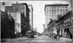
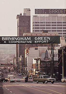
20th Street North is a north-south street in the center of downtown Birmingham which functions as Birmingham's "main street". It is sometimes called Birmingham Green after a rehabilitation project of the early 1970s.
20th Street begins at the northern end of 20th Street South at the Railroad Reservation. From there it first crosses Morris Avenue, and then continues for seven blocks to Park Place where it is terminated by Linn Park.
Short 20th Street is the one-block section of 20th Street between Birmingham City Hall and Linn Park. It was named Nina's Way in honor of Nina Miglionico in 2008. Originally 20th street bounded both sides of the park as East 20th Street and West 20th Street, but the east segment was abandoned as part of a compromise over the placement of the original Birmingham Public Library building in the late 1920s.
After this one-block section, Twentieth Street previously resumed its path to the east between the current locations of Municipal Auditorium and the Birmingham Museum of Art to the present site of the Birmingham-Jefferson Convention Complex. After the I-20/59 bridge was built, this section was closed to traffic and eventually converted into a landscaped walk and fountain. There are other short sections of the street in North Birmingham, north of Oak Hill Cemetery and near Finley Boulevard.
Birmingham Green
The Birmingham Downtown Improvement Association (BDIA) singled out the beautification of 20th Street as one of its major ambitions when it was formed in 1957. The idea was highlighted in Operation New Birmingham's 1960 recommendations for a "Comprehensive Beautification Program" and reiterated in the 1965 "Design for Progress".
As part of the campaign, Mrs. C. I. Dreyfus of the Birmingham Beautification Board proposed renaming 20th Street to "Vulcan Boulevard". The idea was taken up by businessman Temple Tutwiler, who touted the proposal as late as 1973.
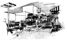
Meanwhile, Tutwiler joined with Reese Murray, Marshall Haynes and Joseph Farley on a volunteer committee to study specific ways to beautify the downtown area. One of their recommendations was to widen sidewalks and add planters and benches to downtown streets, beginning with the seven blocks of 20th Street North, making it more friendly and attractive to pedestrians. New signage, lighting and street furniture would be included in the design. The additional space would be taken from parking and bus lanes, with transit stops moved to 19th Street North.
In 1970, ONB published a "Birmingham Green Plan", according to which $500,000 pledged by business and property owners would be supplemented with equivalent city funds in order to qualify for $1 million in federal grant money. When completed, the $2 million project would also include 19th Street between 1st and 3rd Avenue North and 2nd and 3rd Avenue North between 18th and 21st Street.
Architect James Adams prepared preliminary designs, saying of the proposal "We are knitting the fabric of the central business district with high quality thread -- that thread being the visual impact of the street scene." Planners hoped to attract more people to spend time downtown shopping and strolling. ONB would organize special committees to preserve the budget and to approve the design of specific additions, such as newspaper boxes and telephone booths.
In January 1971, with only 11 of the 425 business and property owners who had agreed to support the project having contributed their pledges, the US Department of Housing and Urban Development released their grant funds. The 20th Street portion of the Birmingham Green project was dedicated on September 14, 1973 at a cost of $1.9 million. The city carried out additional work over the next two years. Meanwhile, building owners leveraged the public investment in streetscaping by making improvements to their properties. B. A. Monaghan began a major renovation of the Nabers, Morrow & Sinnige building at 109–111 20th Street North in 1973.
A two-year $1 million project to extend tree plantings into Southside was completed in 1994.
Notable Locations (south to north)
For an alphabetical list of locations, see the 20th Street North category.
Central City neighborhood
Railroad Reservation
- West side (Block ___)
- 2: Two North Twentieth building (former Relay House, Linn's Park, and L & N Station)
- East side (Block ___)
- 1: former location of U. S. Tire Service (c. 1938)
- 3: former location of Elyton Land Company
- 7 1/2: former location of E. L. Higdon Brokerage Co. and Travelers Protective Association Post B.
- 9: Taylor Building, former headquarters for Superior Mortgage Corporation
Morris Avenue
- West side (Block ___)
- 8-14: former location of the Metropolitan Hotel and Gilbert Hotel
- 10: former location of Moore and Handley, Lontos Restaurant, and Stand n Snack
- Woodward Building, PNC Bank, former headquarters for First American Bank and RBC Bank. Former location of Lane Drugs
- East side (Block ___)
- 1: former location of Elyton Land Company building (Hobson Cafe, P & K Cafe, Borders' Hotel)
- 17: John A. Hand Building, former headquarters for Superior Bank and Cadence Bank. Former location of Joe Wheeler Cafe
1st Avenue North
- West side (Block 99)
- 100-110: Empire Building, former Colonial Bank offices and site of Bank Saloon
- 100: former Green Drug Co. and Colonial Bank branch
- 1st Alley North
- 112: Birmingham Trust building
- 116: former location of Snow & Rambow Saloon
- 124: Webb Building (former site of the Dude Saloon, National Shirt Shop, Yogo's Frosty Frozen Yogurt, Purple Onion, and Pope Jewelers)
- 100-110: Empire Building, former Colonial Bank offices and site of Bank Saloon
- East side (Block 100)
- 101-107: Brown Marx Building (former site of National Bank of Birmingham building)
- 103: former location of B. M. Chenoweth & Company sporting goods
- 105: former location of H. J. Porter Men's Clothiers
- 107: former location of Southern Railway ticket office
- 109–11: Nabers, Morrow & Sinnige building, Advantage Marketing Communications, Engel Hairston & Johanson, former location of Nabers, Morrow & Sinnige drugstore and Thompson's Cafeteria
- 1st Alley North
- 113: Cafe Dupont (former location of 20th Century Bakery)
- 117: former location of Hickman's Kerns Sporting Goods and King Tut Deli
- 119: McKinney-Strahan residence, former location of Utopia Cleaners and Household Finance
- 121: New York Style Delicatessen, former location of Jaffe Jewelry, Stand N' Snack/Sandwich Chef
- 123: Bromberg's building (Bromberg's offices), former location of the Drennen Department Store and Stein's Mens' Clothiers
- 101-107: Brown Marx Building (former site of National Bank of Birmingham building)
2nd Avenue North
- West side (Block 86)
- 200: Roden Block (Parisian)
- 202: former location of Watts Apparel Shop
- 204: former location of Subway Restaurant and Betty Maid Dresses
- 206: former location of Hanover Jewelry
- 208: Joseph McClure Commercial Real Estate (former location of T. L. McGowan & Co. (c. 1889) and W. L. Douglass Shoes
- 210: former location of Sherman's Lanes
- 2nd Alley North
- 212: Iron Age building (former location of Faust Cafe, Mitzi Dress Shop and Thom McAn Shoes)
- 214: Brick & Tin, former location of Busch's Jewelry and Burt's Shoes
- 216: Quizno's Sub, former location of Burt's Shoe Store
- 218: Bistro 218, former location of a boarding house, barber shop, candy store, Bromberg's, Parisian, Hanover Shoes, and Seafood D'Lite
- 220: Farley Building (Classic Basket), former location of Liggett's Drugs
- East side (Block 85)
- 201: Frank Nelson Building, Birmingham School of Law. Former location of A. & A. Ash Jewelers and Woodruff Manufacturing Company
- 203: former location of Flagg Bros. Shoe Store
- 207: Trattoria Centrale (former location of Roma's Italian Bistro)
- 209: former location of United Woolen Mills Clothing Co.
- 211: former location of Royal Hat Co.
- 2nd Alley North
- 213: Cityscape Group, former location of Mayo's Mens' Clothes
- 217: former location of Strauss Mens' Clothes
- 217: former location of Wormser Hat Store, Orange Julius and Sojourns
- 219: Bon Ton Hatters, former location of Studio Book Store and Thom McAn Shoes
- 221: MedTown Pharmacy, former location of Porter Clothing Co. and Shoney's Big Boy
3rd Avenue North
- West side (Block 73)
- 300: Blach's building former location of Butler's Shoe Store and Wallock's
- 302: former location of Lollard's and Terreson's photo printing
- 304: former location of Bronax Jewelers
- 308: former location of Jarman Shoes
- 3rd Alley North
- 314: former location of Lindy Jewelry
- 316: former location of Faust Cafe
- 318: former location of Farmer & Cannon Jewelry Company
- 330: former location of Lane's Drug Store and Hardy Shoe Store
- East side (Block 74)
- 301: Watts Building (1927), Renasant Bank branch, former location of People's Finance & Thrift (former site of Watts Building (1888))
- 303: former location of Regal Shoes
- 305: former location of L & N Railroad ticket office
- 307: former location of Casino Cafe
- 309: former location of Britling Cafeteria No. 2
- 3rd Alley North
- 313: Roly Poly Sandwiches (former location of Alabama Heating & Roofing and the Gaslight Theatre)
- 315: former location of Eleanor's Cards
- 317: former Birmingham Green Postal Station
- 321: Razzleberries; former location of Taylor Optical Co. and Java and Jams
- 323: former location of Ford's Clothes
- 325: former location of Busch's jewelers, McDonald's, Salsa and Sabor, El Mexicano, and Bayou Deli
4th Avenue North
- West side (Block 60)
- 400: Clark Building, former location of Smith & Hardwick and Birmingham Press Club
- 400 1/2: former location of Mary Beard's Restaurant, Cafe Italiano & Piccolino Lounge
- 402: former location of Charles Arndt, clothiers
- 404: former studio of A. C. Keily
- 408: former location of Peerless Laundry
- 410: former location of Harris Florist
- 4th Alley North
- 412: former location of Joy Young Restaurant
- 420: Wells Fargo Tower (formerly SouthTrust Tower and Wachovia Tower), former location of People's Finance & Thrift Co.
- 422: former location of Carr Floral Company
- 424: former location of shooting gallery
- 400: Clark Building, former location of Smith & Hardwick and Birmingham Press Club
- East side (Block 59)
- 401: Birmingham Parking Authority Deck 3
- 403: former location of E. E. Forbes & Sons
- 407: former location of Greenwood's Restaurant
- 4th Alley North
- 417: Regions Plaza former location of Tutwiler Hotel
- 421: former location of Drum Room
5th Avenue North
- West side (Block 47)
- 500 Regions Center (formerly AmSouth-Sonat building), former location of Southern Club and Works Progress Administration. Former location of Occupy Birmingham's "Camp Mayhem"
- 502: former location of Birmingham Athletic Club and YMCA Birmingham
- 5th Alley North
- 530: Regions-Harbert Plaza (formerly AmSouth-Harbert Plaza)
- East side (Block 48)
- 501: Financial Center Building, (Birmingham Regional Chamber of Commerce, Compass Bank branch, Norman, Wood, Kendrick & Turner, Winged Victory statue), former location of Molton Hotel
- 5th Alley North
- 513: Carpenter House
- 529: Cathedral Church of the Advent
6th Avenue North
- West side
- Birmingham Board of Education Parking Deck
- Birmingham Board of Education (proposed location for The Westin Grand Bohemian)
- East side
Park Place
- 20th Street shifts west, becomes known as Nina's Way (formerly Short 20th Street)
- West side
- East side
8th Avenue North
- end of this section of 20th Street
- I-20/59
- 831: former location of Alabama Supply Company
North Birmingham neighborhood
References
- "Whitson's Tenant Map of Birmingham" (1930s)
- "New look for our big town" (August 18, 1970) Birmingham News - via Birmingham Rewound
- Birmingham Area Chamber of Commerce (1976) Century Plus: A Bicentennial Portrait of Birmingham, Alabama 1976 Birmingham: Oxmoor Press, p. 16.
External links
- Photographs of 20th Street North from the Magic City Flickr Group


